 |
This is a file from the Wikimedia Commons. Information from its description page there is shown below.
Commons is a freely licensed media file repository. You can help.
|
Summary
| DescriptionMap of Taungoo Empire (1580).png |
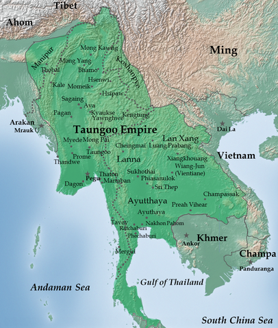
English: Taungoo Empire at its highest extent during the reign of King Bayinnaung (1551-1581)
|
| Date |
21 December 2011 |
| Source |
Own work. Background map is taken from www.naturalearthdata.com (public domain: Terms of Use). |
| Author |
Soewinhan |
References
Refer to the
- Victor B. Lieberman (2003) Strange parallels: Southeast Asia in global context, c 800-1830, Volume 1, pp. 152 ISBN: 0521804965. for the extent of Taungoo Empire as of 1580.
- File:Map of Toungoo Kingdom 1572.jpg and File:Map-of-southeast-asia 900 CE.png for geographic names.
Notes
- The borders at that times were not demarcated. As stated in Berkeley timemap: The level of details present in some boundaries should not be interpreted as a result of a precise, detailed understanding of the borders of states during this period.
Licensing
|
I, the copyright holder of this work, hereby publish it under the following license:
|
File usage
The following pages on Schools Wikipedia link to this image (list may be incomplete):
This file contains additional information, probably added from the digital camera or scanner used to create or digitize it. If the file has been modified from its original state, some details may not fully reflect the modified file.
Through Schools Wikipedia, SOS Children has brought learning to children around the world. SOS Children's Villages is an international children's charity, providing a good home and loving family to thousands of children who have lost their parents. We also work with communities to help vulnerable families stay together and raise children in the best possible environment. Find out how you can help children in other countries.


