
File:SSS Islands Map.png
Size of this preview: 373 × 480 pixels.
| |
This is a file from the Wikimedia Commons. Information from its description page there is shown below.
Commons is a freely licensed media file repository. You can help. |
 |
This map image could be recreated using vector graphics as an SVG file. This has several advantages; see Commons:Media for cleanup for more information. If an SVG form of this image is already available, please upload it. After uploading an SVG, replace this template with {{ vector version available|new image name.svg}}. |
| Description |
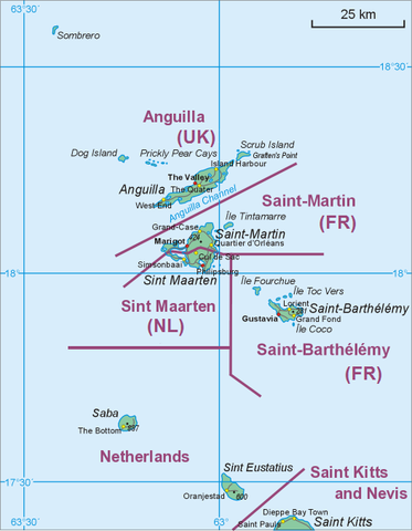
Nederlands: Bovenwindse Eilanden (Anguilla, Saint-Martin/Sint Maarten, Saint-Barthélemy, Saba, Sint Eustatius
Polski: Mapa środkowej części Wysp Podwietrznych (Anguilla, Saint-Martin/Sint Maarten, Saint-Barthélemy, Saba, Sint Eustatius
English: Map of middle part of Leeward Islands (Anguilla, Saint-Martin/Sint Maarten, Saint-Barthélemy, Saba, Sint Eustatius
|
| Date | 17 October 2009 |
| Source | Own work |
| Author | Hanhil based on File:Saint Martin Map.png by Aotearoa |
Licensing
|

File usage
The following pages on Schools Wikipedia link to this image (list may be incomplete):
Want to know more?
Wikipedia for Schools was collected by SOS Childrens Villages. SOS Childrens Villages works in 133 countries and territories across the globe, helps more than 62,000 children, and reaches over 2 million people in total. Want to learn more? Go to http://www.soschildrensvillages.org.uk/sponsor-a-child