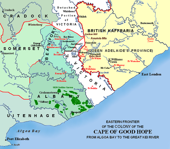
File:Eastern Frontier, Cape of Good Hope, ca 1835.png

Size of this preview: 547 × 480 pixels.
| |
This is a file from the Wikimedia Commons. Information from its description page there is shown below.
Commons is a freely licensed media file repository. You can help. |
Summary
| Description | Eastern frontier of the Cape of Good Hope colony, ca 1835 Settled colonial area, showing districts established in 1820 (in various shades)
Neutral zone since 1820, as agreed by Lord Charles Somerset and the Gaika (Ngqika) tribe of the Xhosas
Tribal areas under British administration
Military forts and district boundaries
Added to the original: Locations of the 1820 British settler farms in the Albany district Notes: Most forts remain today as ruins in various degrees of restoration. Fort Peddie is a blockhouse, built after the 1820 agreement that formed the neutral zone. Fort Brown was much enlarged after the sixth frontier war, became a police post in 1873 and was declared a national monument in 1938. Military villages such as Woburn, Auckland, Ely, Juanasberg, Kempt and Fredericksburg were established in the vicinity of the forts. Alice was a Presbyterian missionary centre which grew around Fort Hare's military encampment. Adelaide, a Scottish settlement near the current town, became a transit camp for troops during the War of Mlanjeni. King Williams Town started as a military camp and mission station and became the base from which Sir Harry Smith controlled the tribal areas. The small village Sidbury was established by settler Richard Daniel, c. 1832. The farming districts of Albany and eastern Uitenhage were also collectively known as the 'Zuurveld'. The Kat River Settlement was a homeland for displaced Khoi-khoi where they occupied land tenures for the mission stations. |
| Date | December 2007 |
| Source | Self-made. JMK 11:03, 26 December 2007 (UTC) Redrawn from source map last published in 1903. The base map may be John Arrowsmith's 1851 Eastern Frontier of the Colony of the Cape of Good Hope, (and part of Kafirland) From Algoa Bay to the Great Kei River. Arrowsmith's lithograph was redrawn and compiled chiefly from M.S. Surveys & Sketches, communicated by Lt. Col. Mitchell late Survr. Genl. of the Colony and Captn. Wm Owen ... |
| Author | I created the map, based partly on the source map: Eastern frontier of the Colony of the Cape of Good Hope from Algoa Bay to the Great Kei river, which appears opposite page 620 of ‘ The autobiography of Lieutenant-general Sir Harry Smith’ by G.C.B. Bart, Chapter xlviii, published 1903, as part of the online Build a Book initiative. |
Licensing
|
![]() The categories of this image should be checked. Check them now!
The categories of this image should be checked. Check them now!
- Remove redundant categories and try to put this image in the most specific category/categories
- Remove this template by clicking here (or on the first line)
File usage on other wikis
Related galleries
File usage
The following pages on Schools Wikipedia link to this image (list may be incomplete):
More information
Schools Wikipedia has made the best of Wikipedia available to students. SOS Children helps those who have nothing and no one, giving them back the famly they have lost and bringing them the very best opportunities for a happy, healthy future. We have helped children in Africa for many years - you can help too...

