 |
This is a file from the Wikimedia Commons. Information from its description page there is shown below.
Commons is a freely licensed media file repository. You can help.
|
| Description |
Deutsch: Local Government Districts von Nordirland
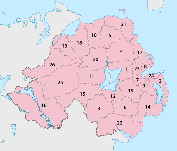
English: Local Government Districts of Northern Ireland
- Antrim
- Ards
- Armagh (City)
- Ballymena
- Ballymoney
- Banbridge
- Belfast (City)
- Carrickfergus
- Castlereagh
- Coleraine
- Cookstown
- Craigavon
- Derry (City)
- Down
- Dungannon and South Tyrone
- Fermanagh
- Larne
- Limavady
- Lisburn (City)
- Magherafelt
- Moyle
- Newry and Mourne
- Newtownabbey
- North Down
- Omagh
- Strabane
|
| Date |
September 2009 |
| Source |
Self made, using this map by NNW |
| Author |
Maximilian Dörrbecker ( Chumwa) |
Permission
( Reusing this file) |
|
I, the copyright holder of this work, hereby publish it under the following license:
|
Sie dürfen das Bild zu den folgenden Bedingungen nutzen:
- Sie müssen den Namen des Autors nennen.
- Im Falle einer Verbreitung müssen Sie anderen die Lizenzbedingungen, unter die dieses Bild fällt, mitteilen.
- Sie müssen das Bild unter gleichen Bedingungen weitergeben. Wenn sie das Bild abändern oder Arbeiten auf diesem Bild aufbauen, müssen Sie das Ergebnis aus dieser Arbeit ebenfalls unter diese Lizenz stellen.
- Jede dieser Bedingungen kann nach schriftlicher Einwilligung des Rechtsinhabers aufgehoben werden.
|
File usage
The following pages on Schools Wikipedia link to this image (list may be incomplete):


