 |
This is a file from the Wikimedia Commons. Information from its description page there is shown below.
Commons is a freely licensed media file repository. You can help.
|
| Description |
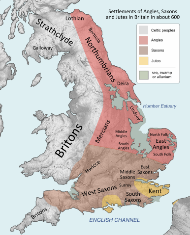
Peoples of Britain circa 600 |
| Date |
circa 600 |
| Source |
Vectorization of File:Britain peoples circa 600.png drawn by User:IMeowbot
border data from CIA, people locations from The Historical Atlas by William R. Shepherd, 1926 edition, with clarifications supplied by en:User:Everyking per references used in en:Penda of Mercia. Anglo-Saxon coastline from Hill, 'An Atlas of Anglo-Saxon England' (1981) (the grey areas marked 'sea, swamp or alluvium' show where little Anglo-Saxon settlement occurred, because (according to Hill) there was at different periods either large areas of mud, marshland or open sea). |
| Author |
User:Hel-hama |
Permission
( Reusing this file) |
 |
Permission is granted to copy, distribute and/or modify this document under the terms of the GNU Free Documentation License, Version 1.2 or any later version published by the Free Software Foundation; with no Invariant Sections, no Front-Cover Texts, and no Back-Cover Texts. A copy of the license is included in the section entitled GNU Free Documentation License. http://www.gnu.org/copyleft/fdl.htmlGFDLGNU Free Documentation Licensetruetrue
|
|
File usage
The following pages on Schools Wikipedia link to this image (list may be incomplete):
This file contains additional information, probably added from the digital camera or scanner used to create or digitize it. If the file has been modified from its original state, some details may not fully reflect the modified file.
This selection has made Wikipedia available to all children. SOS Childrens Villages helps those who have nothing and no one, giving them back the famly they have lost and bringing them the very best opportunities for a happy, healthy future. Help another child by taking out a sponsorship


