
File:Middle east graphic 2003.jpg
| |
This is a file from the Wikimedia Commons. Information from its description page there is shown below.
Commons is a freely licensed media file repository. You can help. |
This image was uploaded in the JPEG format even though it consists of non-photographic data. This information could be stored more efficiently or accurately in the PNG format or SVG format. If possible, please upload a PNG or SVG version of this image without compression artifacts, derived from a non-JPEG source (or with existing artifacts removed). After doing so, please tag the JPEG version with {{ Superseded|NewImage.ext}}, and remove this tag. This tag should not be applied to photographs or scans. For more information, see {{ BadJPEG}}. |
|
Summary
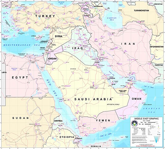
Courtesy of the University of Texas Libraries, The University of Texas at Austin http://www.lib.utexas.edu/maps/middle_east.html
High-resolution political / railway / roadmap of the Middle East from 2003.
Further background at http://erg.usgs.gov/nimamaps/.
The map contains several major errors, for example, Haifa, Israel is located where Acre should be, and Tel Aviv is approximately where Netanya should be.
Licensing
 |
This image is a work of the United States National Geospatial-Intelligence Agency. As a work of the U.S. federal government, the image is in the public domain. English | српски / srpski | +/− |
 |
File usage
The following pages on Schools Wikipedia link to this image (list may be incomplete):
Metadata
Learn more
Wikipedia for Schools brings Wikipedia into the classroom. SOS Children's Villages is famous for the love and shelter it brings to lone children, but we also support families in the areas around our Children's Villages, helping those who need us the most. Sponsoring a child is a great way to help children who need your support.