
File:Columbus1.PNG
Size of this preview: 640 × 373 pixels.
| |
This is a file from the Wikimedia Commons. Information from its description page there is shown below.
Commons is a freely licensed media file repository. You can help. |
| Description |
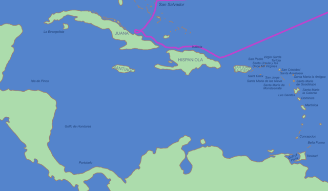
Italiano: Questo è il percorso del primo viaggio di Colombo nei Caraibi. La mappa utilizza i nomi spagnoli con cui Colombo conosceva quei luoghi.
English: This is the route of first voyage of Columbus in the Caribbean. This map shows the Spanish-given names by which Columbus would have known these places.
Česky: Mapa první výpravy Kryštofa Kolumba. Popisky jednotlivých lokalit jsou ve španělštině, jak je znal sám Kolumbus.
|
|||||||||
| Date | ||||||||||
| Source | ||||||||||
| Author | ||||||||||
| Permission ( Reusing this file) |
|

 |
This map image could be recreated using vector graphics as an SVG file. This has several advantages; see Commons:Media for cleanup for more information. If an SVG form of this image is already available, please upload it. After uploading an SVG, replace this template with {{ vector version available|new image name.svg}}. |
File usage
The following pages on Schools Wikipedia link to this image (list may be incomplete):
More information
Wikipedia for Schools was collected by SOS Children. SOS Children's Villages works in 133 countries and territories across the globe, helps more than 62,000 children, and reaches over 2 million people in total. We have helped children in Africa for many years - you can help too...