
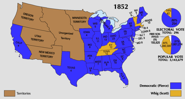
File:1852 Electoral Map.png
- File
- File usage
- Metadata
- Did you know...?
Size of this preview: 640 × 344 pixels.
| |
This is a file from the Wikimedia Commons. Information from its description page there is shown below.
Commons is a freely licensed media file repository. You can help. |
 |
File:1852_US_Electoral_Map.svg is a vector version of this file. It should be used in place of this raster image when superior. File:1852 Electoral Map.png
For more information about vector graphics, read about Commons transition to SVG.
|
 |
| Description |
|
||||
| Date | |||||
| Source | National Atlas of the United States | ||||
| Author | Uploaded by Tallicfan20 | ||||
| Permission ( Reusing this file) |
|


Metadata
Did you know...?
All five editions of Schools Wikipedia were compiled by SOS Childrens Villages. SOS Childrens Villages believes education is an important part of a child's life. That's why we ensure they receive nursery care as well as high-quality primary and secondary education. When they leave school, we support the children in our care as they progress to vocational training or higher education. Sponsoring a child is a great way to help children who need your support.