  | 
          
            This is a file from the  Wikimedia Commons. Information from its  description page there is shown below.  Commons is a freely licensed media file repository.  You can help. 
           | 


          | Public domainPublic domainfalsefalse | 


             | 
          This map has been uploaded by  Electionworld from en.wikipedia.org to enable the   Wikimedia  Atlas of the World   . Original uploader to en.wikipedia.org was  Briangotts, known as  Briangotts at en.wikipedia.org. Electionworld is not the creator of this map. Licensing information is below. | 
         
        
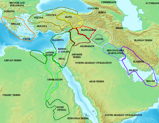
        Map of the ancient  Near East during the  Amarna period, showing the great powers of the period:  Egypt (green),  Hatti (yellow), the  Kassite kingdom of  Babylon (purple),  Assyria (grey), and  Mittani (red). Lighter areas show direct control, darker areas represent spheres of influence. The extent of the  Achaean/ Mycenaean civilization is shown in orange.
        On the map above: the territory between Medes and Iberia was called Ararat or Armenia, around the lake Van.


         Licensing 


           I, the copyright holder of this work, hereby publish it under the following license:
           
            
               | 
             Permission is granted to copy, distribute and/or modify this document under the terms of the  GNU Free Documentation License, Version 1.2 or any later version published by the  Free Software Foundation; with no Invariant Sections, no Front-Cover Texts, and no Back-Cover Texts. A copy of the license is included in the section entitled  GNU Free Documentation License.  http://www.gnu.org/copyleft/fdl.htmlGFDLGNU Free Documentation Licensetruetrue 
              | 


           | 


       File usage
       
        The following pages on Schools Wikipedia link to this image (list may be incomplete):


       This file contains additional information, probably added from the digital camera or scanner used to create or digitize it. If the file has been modified from its original state, some details may not fully reflect the modified file.