
File:Theodosius I's empire.png
Theodosius_I's_empire.png (563 × 406 pixels, file size: 11 KB, MIME type: image/png)
| |
This is a file from the Wikimedia Commons. Information from its description page there is shown below.
Commons is a freely licensed media file repository. You can help. |
 |
This map has been uploaded by Electionworld from en.wikipedia.org to enable the |
| Description |
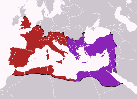
English: Map of the boundaries of the western and eastern Roman empires after the death of Theodosius I, in 395 AD.
Western Roman Empire
Eastern Roman Empire
|
| Date | 17 October 2006 (original upload date) |
| Source | Made personally from Image:BlankMap-Europe-v3.png, using (2004). The Collins Atlas of World History. Wiltshire: HarperCollins, 46-47. 0-00-716640-0. and Image:Roman empire 395.jpg as a source. |
| Author | Geuiwogbil at en.wikipedia |
 |
This map image could be recreated using vector graphics as an SVG file. This has several advantages; see Commons:Media for cleanup for more information. If an SVG form of this image is already available, please upload it. After uploading an SVG, replace this template with {{ vector version available|new image name.svg}}. |
Licensing
|

File usage
The following pages on Schools Wikipedia link to this image (list may be incomplete):
Metadata
Want to know more?
All five editions of Schools Wikipedia were compiled by SOS Children. SOS Children's Villages is a global charity founded in 1949 to give children who have lost everything the childhood they deserve. Sponsoring a child is the coolest way to help.