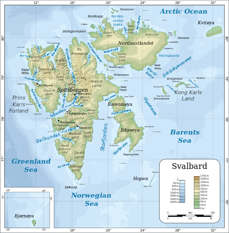
File:Topographic map of Svalbard.svg

| |
This is a file from the Wikimedia Commons. Information from its description page there is shown below.
Commons is a freely licensed media file repository. You can help. |
Summary
|
|
This vector image was created with Inkscape. |
| Description |
English: Topographic map of Svalbard.
Suomi: Huippuvuorten topografinen kartta.
Norsk bokmål: Topografisk kart over Svalbard.
Polski: Mapa topograficzna Svalbardu.
Русский: Топографическая_карта Шпицбергена.
Українська: Топографічна_карта Свальбарда.
|
| Date | 14 February 2008 |
| Source | Self-made in Inkscape by Mysid. Coastline from a CIA map ( Image:Sv-map.png) and topographic data (see below). |
| Author | Oona Räisänen ( Mysid) |
| |
This SVG file uses embedded text that can be easily translated into your language using this automated tool. Learn more. You can also download it and translate it manually using a text editor. العربية | беларуская (тарашкевіца) | bosanski | català | česky | dansk | Deutsch | Ελληνικά | English | Esperanto | español | eesti | فارسی | suomi | français | galego | עברית | hrvatski | magyar | Հայերեն | italiano | 日本語 | ქართული | ភាសាខ្មែរ | 한국어 | lietuvių | македонски | മലയാളം | Bahasa Melayu | Plattdüütsch | Nederlands | norsk nynorsk | norsk bokmål | polski | português | русский | slovenščina | shqip | српски / srpski | svenska | ไทย | Türkçe | татарча/tatarça | українська | Tiếng Việt | Volapük | 中文 | 中文(简体) | +/- |
Licensing
|
File usage
Metadata
| Width | 2497.1875 |
|---|---|
| Height | 2536.7812 |
The best way to learn
Wikipedia for Schools was collected by SOS Children. SOS Children's Villages is a global charity founded in 1949 to give children who have lost everything the childhood they deserve. Find out more about sponsoring a child.

