
File:CIAIranKarteOelGas.jpg
Size of this preview: 467 × 479 pixels.
| |
This is a file from the Wikimedia Commons. Information from its description page there is shown below.
Commons is a freely licensed media file repository. You can help. |
| Description |
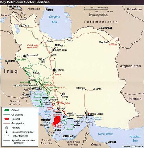
English: Key Petroleum Sector facilities (2004)
Iran (Wall Map) 2004 "Iran Country Profile" Iran map with insets: Population Density, Ethnoreligious Distribution, Key Petroleum Sector Facilities, Southern Caspian Energy Prospects and Strait Of Hormuz (2.5M) (source: CIA map) http://www.lib.utexas.edu/maps/middle_east_and_asia/iran_country_profile_2004.jpg |
| Date | 20 October 2008 (original upload date) |
| Source | Transferred from en.wikipedia; transferred to Commons by User:Teratornis using CommonsHelper. |
| Author | Original uploader was SSZ at en.wikipedia |
| Permission ( Reusing this file) |
PD-USGOV-CIA. |
Licensing
 |
This image is a work of a Central Intelligence Agency employee, taken or made as part of that person's official duties. As a Work of the United States Government, this image or media is in the public domain.
|
 |
 |
This map image could be recreated using vector graphics as an SVG file. This has several advantages; see Commons:Media for cleanup for more information. If an SVG form of this image is already available, please upload it. After uploading an SVG, replace this template with {{ vector version available|new image name.svg}}. |
File usage
The following pages on Schools Wikipedia link to this image (list may be incomplete):
Schools Wikipedia facts
Learning is fun and easy with Schools Wikipedia. SOS Childrens Villages is famous for the love and shelter it brings to lone children, but we also support families in the areas around our Children's Villages, helping those who need us the most. There are many ways to help with SOS Children.