
File:St helens map showing 1980 eruption deposits.png
| |
This is a file from the Wikimedia Commons. Information from its description page there is shown below.
Commons is a freely licensed media file repository. You can help. |
| Description |
English: replacing jpeg version, and cropping out extraneous text.
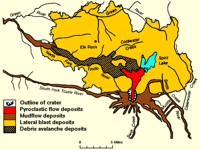
Map of the area around Mount St. Helens which were affected by the May 18, 1980 eruption. North is to the top. USGS image from |
| Date | 27 December 2007 (original upload date) |
| Source | Transferred from en.wikipedia; transferred to Commons by User:Phatom87 using CommonsHelper. |
| Author | Original uploader was Peteforsyth at en.wikipedia |
| Permission ( Reusing this file) |
PD-USGOV-INTERIOR-USGS. |
Licensing
 |
This image is in the public domain because it contains materials that originally came from the United States Geological Survey, an agency of the United States Department of the Interior. For more information, see the official USGS copyright policy. български | català | Deutsch | English | español | eesti | suomi | français | galego | italiano | 한국어 | македонски | മലയാളം | Nederlands | polski | português | русский | Türkçe | 中文 | 中文(简体) | +/− |
|
 |
This map image could be recreated using vector graphics as an SVG file. This has several advantages; see Commons:Media for cleanup for more information. If an SVG form of this image is already available, please upload it. After uploading an SVG, replace this template with {{ vector version available|new image name.svg}}. |
File usage
What is Schools Wikipedia?
Wikipedia for Schools is one of SOS Children's Villages' many educational projects. SOS Childrens Villages is an international children's charity, providing a good home and loving family to thousands of children who have lost their parents. We also work with communities to help vulnerable families stay together and raise children in the best possible environment. Help another child by taking out a sponsorship