  | 
          
            This is a file from the  Wikimedia Commons. Information from its  description page there is shown below.  Commons is a freely licensed media file repository.  You can help. 
           | 


        Summary 


           | Description | 
           
            
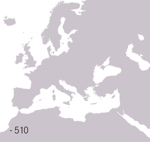
             English: Animated map of the Roman Republic and Empire. Displayed in the map:    Roman republic 510BC-40BC 
                  Roman Empire 20AD-360AD 
                  Eastern Roman Empire 405AD-1453AD 
                  Western Roman Empire 405AD-480AD  Years shown: 510BC, 320BC, 300BC, 270BC, 220BC, 190BC, 140BC, 70BC, 40BC, 20AD, 70AD, 140AD, 230AD, 300AD, 360AD, 405AD, 420AD, 450AD, 480AD, 530AD.  
             Français: Carte animée de la république puis de l'empire Romain.
                   République romaine : de -510 à -40. 
                  Empire romain : de 20 à 360. 
                  Empire romain d'Orient : de 405 à 1453. 
                  Empire romain d'Occident : de 405 à 480.  Années montrées sur la carte : -510, -320, -300, -270, -220, -190, -140, -70, -40, 20, 70, 140, 230, 300, 360, 405, 420, 450, 480, 530.  
             
            | 
          
          
           | Date | 
           6 June 2006 | 
          
          
           | Source | 
           
            
             English:
              
               - Background map based on  Image:BlankMap-Europe-v3.png
 
               - Data from: 
                 - Colin McEvedy, Penguin Atlas of Ancient History
 
                 - John Haywood, Atlas of Past Times
 
                 - DK Atlas of world history


               - See also maps at external links,  four stage animated map of the roman empire,  more detailed animated map of roman empire


             Français:
              
               - Fond de carte basé sur  Image:BlankMap-Europe-v3.png
 
               - Source des données : 
                 - Colin McEvedy, Penguin Atlas of Ancient History
 
                 - John Haywood, Atlas of Past Times
 
                 - DK Atlas of world history


               - Voir aussi ces cartes : 


            | 
          
          
           | Author | 
            Roke ( d) | 


          | 
            Camera location 
           | 
          
             47° 0′ 0.0″ N, 18° 0′ 0.0″ E 
           | 
          This and other images at their locations on:  Google Maps -  Google Earth -  OpenStreetMap | 
          ( Info)47;18 | 
         
        
        Licensing 


           I, the copyright holder of this work, hereby publish it under the following license:
           
            
               | 
             Permission is granted to copy, distribute and/or modify this document under the terms of the  GNU Free Documentation License, Version 1.2 or any later version published by the  Free Software Foundation; with no Invariant Sections, no Front-Cover Texts, and no Back-Cover Texts. A copy of the license is included in the section entitled  GNU Free Documentation License.  http://www.gnu.org/copyleft/fdl.htmlGFDLGNU Free Documentation Licensetruetrue 
              | 


           | 


       File usage
       
        The following pages on Schools Wikipedia link to this image (list may be incomplete):