
File:Location Irish Free State in dark green and claimed Territory in light green.png
Location_Irish_Free_State_in_dark_green_and_claimed_Territory_in_light_green.png (222 × 115 pixels, file size: 5 KB, MIME type: image/png)
| |
This is a file from the Wikimedia Commons. Information from its description page there is shown below.
Commons is a freely licensed media file repository. You can help. |
 |
This map image could be recreated using vector graphics as an SVG file. This has several advantages; see Commons:Media for cleanup for more information. If an SVG form of this image is already available, please upload it. After uploading an SVG, replace this template with {{ vector version available|new image name.svg}}. |
Summary
| Description |
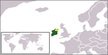
English: Location of the Irish Free State in Dark Green Claimed Territory of the Irish Free State in Light Green.
|
| Date | 22 August 2011 |
| Source | Own work |
| Author | IJA |
Licensing
|
File usage
The following pages on Schools Wikipedia link to this image (list may be incomplete):
Did you know...?
SOS Childrens Villages has brought Wikipedia to the classroom. The world's largest orphan charity, SOS Children's Villages brings a better life to more than 2 million people in 133 countries around the globe. Would you like to sponsor a child?