
File:KatrinaNewOrleansFlooded edit2.jpg
| |
This is a file from the Wikimedia Commons. Information from its description page there is shown below.
Commons is a freely licensed media file repository. You can help. |
| |
This is a featured picture, which means that members of the community have identified it as one of the finest images on the English Wikipedia, adding significantly to its accompanying article. If you have a different image of similar quality, be sure to upload it using the proper free license tag, add it to a relevant article, and nominate it. |
| |
This image was selected as picture of the day on the English Wikipedia for August 29, 2008. |
|
||||||
| This is a retouched picture, which means that it has been digitally altered from its original version. Modifications: selective noise reduction. The original can be viewed here: KatrinaNewOrleansFlooded.jpg. Modifications made by Mfield.
|
Summary
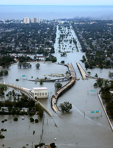
| Description | New Orleans, Louisiana in the aftermath of Hurricane Katrina (2005:08:29 17:24:22), showing Interstate 10 at West End Boulevard, looking towards Lake Pontchartrain. The 17th Street Canal is just beyond the left edge of the image. The breach in the levee of that canal was responsible for much of the flooding of the city in the hours after the hurricane. In the foreground, the intersection is the juncture of I-10, running from the bottom of the photo and curving out of the photo to the left, with the western end of I-610, which extends off the photo from the centre right, and the West End entrance/exit from I-10. The block shaped building at centre left front is a pumping station, one of those used to pump water from heavy rains off city streets in more normal times. The far eastern end of Veterans Memorial Boulevard is seen just back from the interchange extending to the left. The view looks north toward Lake Pontchartrain. The stretch of ground with no buildings from the Interchange to the lake is Pontchartrain Blvd. (on the left) and West End Blvd. (on the right), with a linear park (formerly the route of the New Basin Canal) between them. Smoke can be seen rising near the lake, probably from the burning of the Southern Yacht Club building. This photo provided by the U.S. Coast Guard shows flooded roadways as the Coast Guard conducted initial Hurricane Katrina damage assessment overflights of New Orleans, Monday Aug. 29, 2005. Edit, selective noise reduction by Mfield Deutsch: Das überflutete New Orleans
Español: La ciudad de Nueva Orleans, después del paso del Katrina. La foto muestra la carretera Interestatal 10 despues del huracan.
Suomi: 80% New Orleansista jäi veden alle, kun hurrikaani Katrina iski Yhdysvaltain rannikolle elokuussa 2005
Türkçe: Sel altında kalan I-10/I-610/West End Bulvarlarının kesiştiği kavşak, kuzeybatı New Orleans ve Metairie, Louisiana.
|
|||
| Date | 29 August 2005 | |||
| Source | Published here, here, and here | |||
| Author | AP Photo/U.S. Coast Guard, Petty Officer 2nd Class Kyle Niemi | |||
| Permission ( Reusing this file) |
|

File usage
The following pages on Schools Wikipedia link to this image (list may be incomplete):
Metadata
Learn more about Schools Wikipedia
Wikipedia for Schools is one of SOS Childrens Villages' many educational projects. Thanks to SOS Childrens Villages, 62,000 children are enjoying a happy childhood, with a healthy, prosperous future ahead of them. Find out more about sponsoring a child.