
File:Greek Colonization.png
Size of this preview: 640 × 363 pixels.
| |
This is a file from the Wikimedia Commons. Information from its description page there is shown below.
Commons is a freely licensed media file repository. You can help. |
Summary
| Description |
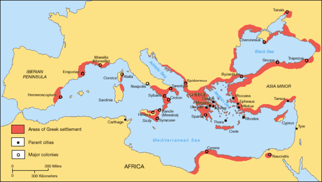
English: A map showing the Greek territories and colonies during the Archaic period.
Nederlands: Een kaart met de Griekse territoria en kolonies gedurende de Archaïsche periode.
|
| Date | 13:42, 15 October 2010 (UTC) |
| Source | Own work |
| Author | Based on a map in The Times History Atlas of the World |
Licensing
 |
I, the copyright holder of this work, release this work into the public domain. This applies worldwide. In some countries this may not be legally possible; if so: I grant anyone the right to use this work for any purpose, without any conditions, unless such conditions are required by law.
|
File usage
The following pages on Schools Wikipedia link to this image (list may be incomplete):
Metadata
About Schools Wikipedia
Schools Wikipedia has made the best of Wikipedia available to students. The world's largest orphan charity, SOS Children's Villages brings a better life to more than 2 million people in 133 countries around the globe. Sponsoring a child is a great way to help children who need your support.