
File:Europe land use map.png
Summary
| Description |
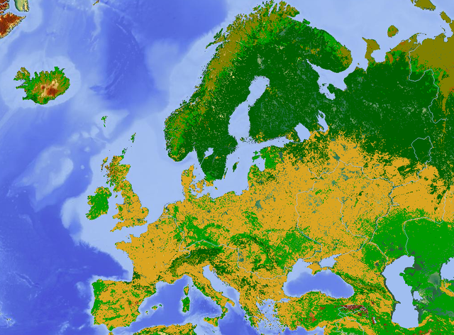
A map of land use in Europe. Yellow: cropland and arable, light green: grassland and pasture, dark green: forest, light brown: tundra or bogs, unshaded areas: other (including towns and cities). Underlying map is a terrain map. |
|---|---|
| Source |
Created from http://www.maps-for-free.com/ |
| Date |
10:12, 30 April 2011 (UTC) |
| Author |
Kentynet ( talk) 10:12, 30 April 2011 (UTC) |
| Permission ( Reusing this file) |
See below.
|
Licensing
 |
Permission is granted to copy, distribute and/or modify this document under the terms of the GNU Free Documentation License, Version 1.2 or any later version published by the Free Software Foundation; with no Invariant Sections, no Front-Cover Texts, and no Back-Cover Texts. |
 |
This is a candidate to be copied to Wikimedia Commons. Freely licensed or public domain media are more accessible to other Wikimedia projects if placed on Commons. Any user may perform this move—please see Moving images to the Commons for more information. Please thoroughly review the copyright status of this file and ensure that it is actually eligible for transfer to Commons. If you are concerned that this file could have problems with its attribution information and/or copyright status, then remove this notice and DO NOT transfer it to Commons. By transferring this file to Commons, you acknowledge you have read this message and are willing to accept any and all consequences for inappropriate transfers. Repeat violators will be blocked from editing. If you have checked the file and it is OK to move to Commons add "|human=username" to the template so other users can see it has been checked and can help you copy the file to Commons. If the file has already been moved to Commons, then consider nominating the file for deletion or changing the template to {{Already moved to Commons}} If the file can't be moved to Commons because it doesn't fit Common's scope, then use {{Do not move to Commons|reason=Why it can't be moved to Commons}} If you think that a local copy of this file should be kept, then use {{Keep local}}. Consider using {{Keep local|reason=Why the English Wikipedia needs a local copy}} Copy to Commons: via CommonsHelper |
||
|
|||
File usage
Find out about Schools Wikipedia
SOS Children's Villages chose the best bits of Wikipedia to help you learn. In 133 nations around the world, SOS Children's Villages works to bring better education and healthcare to families in desperate need of support. Go to http://www.soschildrensvillages.org.uk/sponsor-a-child to sponsor a child.