 |
This is a file from the Wikimedia Commons. Information from its description page there is shown below.
Commons is a freely licensed media file repository. You can help.
|
 |
This image was previously a featured picture, but community consensus determined that it no longer meets our featured-picture criteria. If you have a high-quality image that you believe meets the criteria, be sure to upload it, using the proper free-license tag, then add it to a relevant article and nominate it. |
| |
This image was selected as picture of the day on the English Wikipedia for October 18, 2005. |
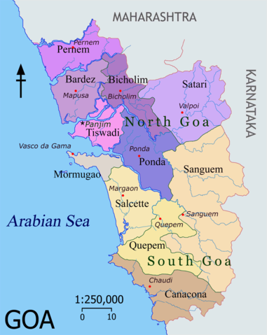
Map of Goa, (an Indian state) featuring depicting their Talukas (district subdivisions) and headquarters.
Colour coding
Goa is divided into two administrative districts: North Goa and South Goa
- Talukas in purple shades belong to North Goa
- Talukas in orange shades belong to South Goa
|
|
|

|
  This formerly was a featured picture on the English language Wikipedia ( Featured pictures) and was considered one of the finest images. This formerly was a featured picture on the English language Wikipedia ( Featured pictures) and was considered one of the finest images.
If you think this file should be featured on Wikimedia Commons as well, feel free to nominate it.
If you have an image of similar quality that can be published under a suitable copyright license, be sure to upload it, tag it, and nominate it.
|
|
|
I, the copyright holder of this work, hereby publish it under the following licenses:
 |
Permission is granted to copy, distribute and/or modify this document under the terms of the GNU Free Documentation License, Version 1.2 or any later version published by the Free Software Foundation; with no Invariant Sections, no Front-Cover Texts, and no Back-Cover Texts. A copy of the license is included in the section entitled GNU Free Documentation License. http://www.gnu.org/copyleft/fdl.htmlGFDLGNU Free Documentation Licensetruetrue
|
You may select the license of your choice.
|
Image made by me. Post a message on my English talk page if you need a translated map. Nichalp 18:29, 31 Mar 2005 (UTC)
 |
This map image could be recreated using vector graphics as an SVG file. This has several advantages; see Commons:Media for cleanup for more information. If an SVG form of this image is already available, please upload it. After uploading an SVG, replace this template with {{ vector version available|new image name.svg}}. |
File usage
The following pages on Schools Wikipedia link to this image (list may be incomplete):
