
File:United States 1842-1845-03.png
Size of this preview: 640 × 433 pixels.
| |
This is a file from the Wikimedia Commons. Information from its description page there is shown below.
Commons is a freely licensed media file repository. You can help. |
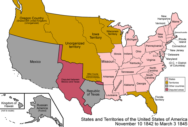
| Description | Map of the states and territories of the United States as it was from 1842 to March 1845. On November 10 1842, a treaty settled all border disputes with lands held by the United Kingdom. On March 3 1845, Florida Territory was admitted as the state of Florida. |
| Date | |
| Source | Own work |
| Author | Made by User:Golbez. |
| Permission ( Reusing this file) |
Own work, attribution required (Multi-license with GFDL and Creative Commons CC-BY 2.5) |
|

| Territorial evolution maps of the United States |
| v · d (template shows date of beginning of change yyyy-mm-dd) |
| 1789-03, 1789-08, 1790-04, 1790-05, 1791-03, 1791-09, 1792-03, 1792-06, 1795, 1796, 1798, 1800-07-04, 1800-07, 1802, 1803-03, 1803-04, 1804-03, 1804-10, 1805-01, 1805-07, 1809, 1810-04, 1810-10, 1812-04, 1812-05, 1812-06, 1816, 1817-03, 1817-12, 1818-10, 1818-12, 1819-03, 1819-12, 1820, 1821-07, 1821, 1822, 1824, 1828, 1834, 1836-03, 1836-06, 1836-07, 1837-01, 1837-03, 1838, 1842, 1845-03, 1845-12, 1846-06, 1846-12, 1848-02, 1848-05, 1848-08, 1849, 1850, 1853-03, 1853-12, 1854, 1858, 1859, 1860, 1861-01, 1861-02-04, 1861-02-28, 1861-03, 1861-08, 1862, 1863-02, 1863-03, 1863-06, 1864-05, 1864-10, 1865, 1866, 1867-01, 1867-03, 1867-10, 1868, 1876, 1884, 1889-11-02, 1889-11-08, 1889-11-11, 1890-05, 1890-07-03, 1890-07-10, 1896-01, 1896-05, 1898, 1907, 1912-01, 1912-02, 1912-08, 1959-01, 1959-08 |
File usage
The following pages on Schools Wikipedia link to this image (list may be incomplete):
I want to learn more...
Through Schools Wikipedia, SOS Childrens Villages has brought learning to children around the world. SOS Childrens Villages helps more than 2 million people across 133 countries around the world. There are many ways to help with SOS Childrens Villages.