 |
This is a file from the Wikimedia Commons. Information from its description page there is shown below.
Commons is a freely licensed media file repository. You can help.
|
Summary
| Description |
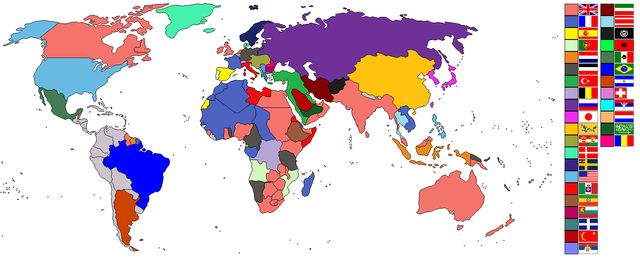
World empires and colonies around World War I.png
English:
- Taken from old colonialism wikipedia map and outlined.
- Dated around 1900 (shows Italian - although the flag is not correct - North Africa post 1910 and Austro-Hungarian Empire circa WW1). British territories of Canada, Australia, New Zealand and South Africa would later become dominions.
- Nations involved with imperialism, directly or indirectly, are coloured. Meant to portray the world around the time of WWI.
- In case anyone wonders, the red flag with the yellow crescent and star is the Rashidi house and their allies. Below them are the Saudis and their allies.
- Grey countries may be smaller empires ( Nepal and Bhutan) or have extended their geopolitical boundaries over unsettled/inhabitated areas (i.e. Latin America such as Chile acquired Easter Island and the Antarctic Peninsula).
|
| Date |
2 August 2007 (original upload date) |
| Source |
Taken from wikipedia map |
| Author |
See below. |
 |
This map image could be recreated using vector graphics as an SVG file. This has several advantages; see Commons:Media for cleanup for more information. If an SVG form of this image is already available, please upload it. After uploading an SVG, replace this template with {{ vector version available|new image name.svg}}. |
Licensing
Ishvara7 at English Wikipedia, the copyright holder of this work, hereby publishes it under the following licenses:
 |
Permission is granted to copy, distribute and/or modify this document under the terms of the GNU Free Documentation License, Version 1.2 or any later version published by the Free Software Foundation; with no Invariant Sections, no Front-Cover Texts, and no Back-Cover Texts. A copy of the license is included in the section entitled GNU Free Documentation License. http://www.gnu.org/copyleft/fdl.htmlGFDLGNU Free Documentation Licensetruetrue
|
You may select the license of your choice.
|
File usage
The following pages on Schools Wikipedia link to this image (list may be incomplete):
