 |
This is a file from the Wikimedia Commons. Information from its description page there is shown below.
Commons is a freely licensed media file repository. You can help.
|
| Description |
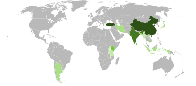
Detailed SVG map with grouping enabled to connect all non-contiguous parts of a country's territory for easy colouring. Smaller countries can also be represented by larger circles to show their data easier. A thorough description of use and other instructions can be found on the instruction page for the non-compact map. This is a more compact version of BlankMap-World6.svg where Antarctica has been removed. Please make any updates primarily to the other map since this one should be keept as identical to the original as possible. |
| Date |
2010-02-02 22:29 (UTC) |
| Source |
|
| Author |
- derivative work: Sjschen ( talk)
|
 |
This is a retouched picture, which means that it has been digitally altered from its original version. Modifications: Added FAO information on tea production in 2008 mapped to colour Tea not grown in significant quantities
From 0.5 to 1%.
From 1 to 5%.
From 5 to 10%.
From 10 to 20%.
More than 20% . The original can be viewed here: BlankMap-World6,_compact.svg. Modifications made by Sjschen.
|
I, the copyright holder of this work, hereby publish it under the following license:
| Public domainPublic domainfalsefalse |
 |
I, the copyright holder of this work, release this work into the public domain. This applies worldwide.
In some countries this may not be legally possible; if so:
I grant anyone the right to use this work for any purpose, without any conditions, unless such conditions are required by law.Public domainPublic domainfalsefalse
|
|
File usage
The following pages on Schools Wikipedia link to this image (list may be incomplete):
This file contains additional information, probably added from the digital camera or scanner used to create or digitize it. If the file has been modified from its original state, some details may not fully reflect the modified file.
SOS Childrens Villages aims to make Wikipedia suitable for young learners. SOS Children is famous for the love and shelter it brings to lone children, but we also support families in the areas around our Children's Villages, helping those who need us the most. You can help by sponsoring a child.


