
File:ElectoralCollege1892.svg
| |
This is a file from the Wikimedia Commons. Information from its description page there is shown below.
Commons is a freely licensed media file repository. You can help. |
| U.S. presidential election maps ( SVG) |
| See also: National Atlas maps (png) |
|
1789 · 1792 · 1796 · 1800 · 1804 · 1808 · 1812 · 1816 · 1820 · 1824 · 1828 · 1832 · 1836 · 1840 · 1844 · 1848 · 1852 · 1856 · 1860 · 1864 · 1868 · 1872 · 1876 · 1880 · 1884 · 1888 · 1892 · 1896 · 1900 · 1904 · 1908 · 1912 · 1916 · 1920 · 1924 · 1928 · 1932 · 1936 · 1940 · 1944 · 1948 · 1952 · 1956 · 1960 · 1964 · 1968 · 1972 · 1976 · 1980 · 1984 · 1988 · 1992 · 1996 · 2000 · 2004 · 2008 · 2012 |
|
(this template: · view · discuss) |
Summary
| Description |
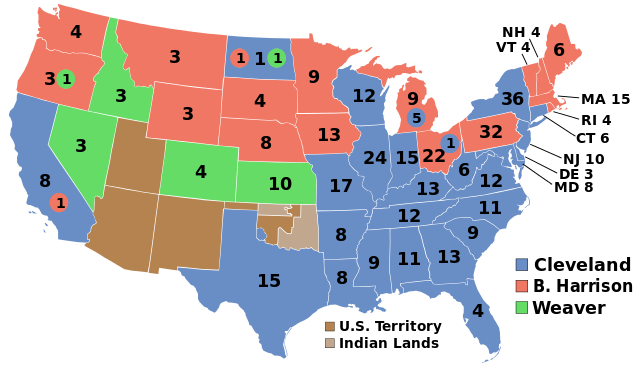
English: Electoral college map for the 1892 United States presidential election.
|
| Date | 2008-12-31 (Original); 2009-10-10 (Current) |
| Source | This image was adapted from File:ElectoralCollege1964.svg (itself based off File:Blank_US_Map.svg) using data from Cherokee Heritage Centre Historical Maps, the original version uploaded by AndyHogan14 and the National Atlas of the United States |
| Author | Cg-realms (current) AndyHogan14 (original) |
Licensing
 |
I, the copyright holder of this work, release this work into the public domain. This applies worldwide. In some countries this may not be legally possible; if so: I grant anyone the right to use this work for any purpose, without any conditions, unless such conditions are required by law.
|
SVG Support
This document is in the Scalable Vector Graphic format (SVG) and requires a supported browser (Opera 9, Firefox 2+) or a SVG plugin for Internet Explorer and other browsers. SVG is an open source format, which means this map can be downloaded and modified/translated completely using a vector graphics editor like Adobe Illustrator or Inkscape (free) or a text editor such as Notepad.
| BLANK THUMBNAIL | View large PNG | View medium PNG | SVG Plugin for Internet Explorer and other browsers |
|---|---|---|---|
| Click here (purge cache) and then CTRL+F5 to reload. Help? | Try 1 Try 2 | Try 1 Try 2 | Adobe SVG plugin |
| Recommended browser | More Help | ||
| Opera 9.1 | List of SVG tools |
File usage
Metadata
Wikipedia for Schools...
All five editions of Schools Wikipedia were compiled by SOS Childrens Villages. In 133 nations around the world, SOS Children's Villages works to bring better education and healthcare to families in desperate need of support. Will you help another child today?