
File:Panama-canal-shepherd-map.png
Size of this preview: 639 × 232 pixels.
| |
This is a file from the Wikimedia Commons. Information from its description page there is shown below.
Commons is a freely licensed media file repository. You can help. |
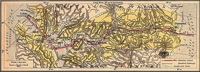
| Description | English: Historical map of the Panama Canal.
|
|||||||||||||||||||
| Date | September 2005 | |||||||||||||||||||
| Source |
|
|||||||||||||||||||
| Author |
|
|||||||||||||||||||
 |
This media file is in the public domain in the United States. This applies to U.S. works where the copyright has expired, often because its first publication occurred prior to January 1, 1923. See this page for further explanation. |
|
|
|
This image might not be in the public domain outside of the United States; this especially applies in the countries and areas that do not apply the rule of the shorter term for US works, such as Canada, Mainland China (not Hong Kong or Macao), Germany, Mexico, and Switzerland. The creator and year of publication are essential information and must be provided. See Wikipedia:Public domain and Wikipedia:Copyrights for more details. |
File usage
The following pages on Schools Wikipedia link to this image (list may be incomplete):
About Schools Wikipedia
SOS Childrens Villages chose the best bits of Wikipedia to help you learn. SOS Children's Villages cares for children who have lost their parents. Our Children's Villages give these children a new home and a new family, while a high-quality education and the best of medical care ensures they will grow up with all they need to succeed in adult life. Find out how you can help children in other countries.