
File:Tokyo Landsat.jpg
Size of this preview: 614 × 480 pixels.
| |
This is a file from the Wikimedia Commons. Information from its description page there is shown below.
Commons is a freely licensed media file repository. You can help. |
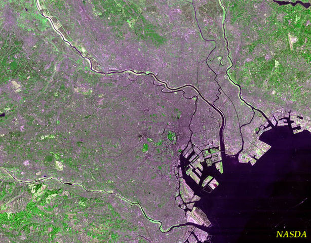
Tokyo Landsat Image. A guided tour:
- The green circle in the centre is the Kokyo (Imperial Palace). The little gray ball in the middle is the palace itself: you can also barely see the Budokan at the top of the palace grounds.
- At the bottom of the photo, on the bay, Tokyo International Airport. The third runway was under construction at the time (or maybe it's just discolored).
- The large artificial islands in the bay near central Tokyo is Odaiba.
- The green blotches west of the Kokyo are the Akasaka Palace and Jingu Park: the big blob far to the west is Yoyogi Park.
- The black spot to the north of Yoyogi Park is central Shinjuku.
- The river on the south side of the photo is the Tama River, separating Tokyo from Kanagawa Prefecture.
- The second river due east of the Palace is the Arakawa, separating Tokyo from Chiba Prefecture.
- The northwestern corner of the map is in Saitama Prefecture, I think (but it's hard to tell exactly where Saitama begins).
 |
This file is in the public domain because it was solely created by NASA. NASA copyright policy states that "NASA material is not protected by copyright unless noted". (See Template:PD-USGov, NASA copyright policy page or JPL Image Use Policy.) |
 |
 |
Warnings:
|
derivative works
Derivative works of this file:
File usage
The following pages on Schools Wikipedia link to this image (list may be incomplete):
Schools Wikipedia and SOS Children
All five editions of Schools Wikipedia were compiled by SOS Children's Villages. In 133 nations around the world, SOS Children works to bring better education and healthcare to families in desperate need of support. Have you thought about sponsoring a child?