
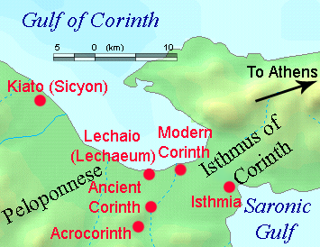
File:Lechaeum.png
| |
This is a file from the Wikimedia Commons. Information from its description page there is shown below.
Commons is a freely licensed media file repository. You can help. |
Contents |
Summary
Map of area around ancient Lecaheum, near Corinth. The Corinthian Canal has been erased from the map.
Locations were judged from a variety of sources including maps of University of Chicago excavations and from Planetware.com for the ancient sites.
Other versions
Image:Lechaeum.svg, Image:Lechaeum-es.svg
 |
File:Lechaeum.svg is a vector version of this file. It should be used in place of this raster image when superior. File:Lechaeum.png
For more information about vector graphics, read about Commons transition to SVG.
|
 |
Licensing
DEMIS World Map Server generated this map from Public Domain sources. DEMIS does not claim any rights over the resultant image ( ). Addition of towns and captions, and alteration to remove the modern Corinthian Canal, were performed on 13 April 2006 by User:TheGrappler, the uploader, who releases all associated rights.
 |
I, the copyright holder of this work, release this work into the public domain. This applies worldwide. In some countries this may not be legally possible; if so: I grant anyone the right to use this work for any purpose, without any conditions, unless such conditions are required by law.
|
|
This image is in the public domain because it came from the site http://www.demis.nl/home/pages/Gallery/examples.htm and was released by the copyright holder. Permission is granted to copy, distribute and/or modify this map since it is based on free of copyright images from: www.demis.nl. See also approval email on de.wp and its clarification.
|
derivative works
Derivative works of this file:
File usage
Want to know more?
Wikipedia for Schools is one of SOS Children's many educational projects. SOS Childrens Villages is there for the children in our care until they are ready for independence. Have you thought about sponsoring a child?