
File:Europe20000ya.png
Size of this preview: 640 × 426 pixels.
| |
This is a file from the Wikimedia Commons. Information from its description page there is shown below.
Commons is a freely licensed media file repository. You can help. |
Summary
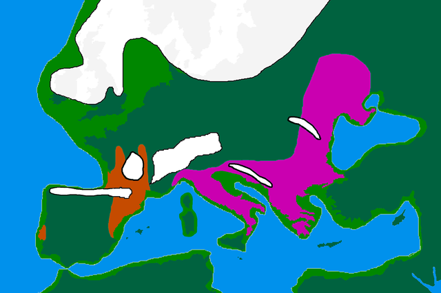
| Description | map of Europe 20,000 years ago. |
| Date | 25 Februare 2007 |
| Source | made by me from Image:BlankMap-Europe-v3.png, which is GFDL v1.2, outline of ancient coast and extent of ice added by me from information from "After the Ice: A Global History" by Steve Mithen. Information about human refugia from "Origins of the British" by Stephen Oppenheimer and "Out of Eden by Stephen Oppenheimer. These were sketched in by me from information supplied by these books. Coloured areas are the furthest extent of the cultures between 15 kya and 20 kya. Solutrean and Proto Solutrean Cultures; Franco-Cantabrian region
Epi Gravettian Culture
|
| Author | User:Wobble |
| Permission ( Reusing this file) |
GFDL |
Licensing
 |
Permission is granted to copy, distribute and/or modify this document under the terms of the GNU Free Documentation License, Version 1.2 or any later version published by the Free Software Foundation; with no Invariant Sections, no Front-Cover Texts, and no Back-Cover Texts. A copy of the license is included in the section entitled GNU Free Documentation License.
|
| This file is licensed under the Creative Commons Attribution-Share Alike 3.0 Unported license. | ||
|
||
| This licensing tag was added to this file as part of the GFDL licensing update.
|
File usage
The following pages on Schools Wikipedia link to this image (list may be incomplete):
The best way to learn
Wikipedia for Schools is one of SOS Childrens Villages' many educational projects. More than 2 million people benefit from the global charity work of SOS Childrens Villages, and our work in 133 countries around the world is vital to ensuring a better future for vulnerable children. Sponsoring a child is the coolest way to help.