
File:Refugees in Congo.jpeg
Size of this preview: 640 × 426 pixels.
| |
This is a file from the Wikimedia Commons. Information from its description page there is shown below.
Commons is a freely licensed media file repository. You can help. |
Summary
| Description |
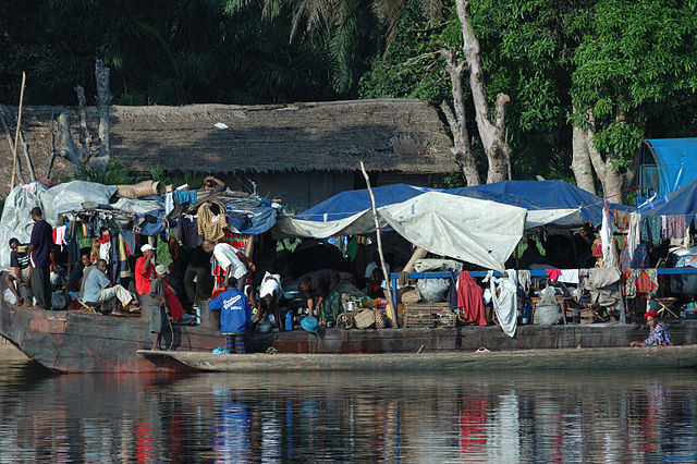
English: The Congo river was the link between Kisangani and Kinshasa. Before the war huge barges plied the river carrying agricultural produce down river and industrial goods up. The war brought this to an end. Today the banks of the river are littered with the rusting hulks of a transport system that has collapsed. People are living in makeshift tents between the stacks of goods on the decks.
|
| Date | 14 February 2008 |
| Source | http://www.flickr.com/photos/julien_harneis/2293424781/ |
| Author | Julien Harneis |
|
Camera location |
|
This and other images at their locations on: Google Maps - Google Earth - OpenStreetMap | ( Info) |
|---|
Licensing
| This file is licensed under the Creative Commons Attribution-Share Alike 2.0 Generic license. | ||
|
| This image was originally posted to Flickr by Julien Harneis at http://flickr.com/photos/16935515@N00/2293424781. It was reviewed on 7 December 2008 by the FlickreviewR robot and was confirmed to be licensed under the terms of the cc-by-sa-2.0. |
File usage
The following pages on Schools Wikipedia link to this image (list may be incomplete):
Metadata
Schools Wikipedia and SOS Children
SOS Children's Villages has brought Wikipedia to the classroom. Thanks to SOS Children's Villages, 62,000 children are enjoying a happy childhood, with a healthy, prosperous future ahead of them. If you'd like to help, learn how to sponsor a child.