
File:Ostrogothic Kingdom.png
Ostrogothic_Kingdom.png (536 × 284 pixels, file size: 35 KB, MIME type: image/png)
| |
This is a file from the Wikimedia Commons. Information from its description page there is shown below.
Commons is a freely licensed media file repository. You can help. |
Summary
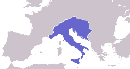
Español: Reino ostrogodo en Italia
Map of the location and extent of the Ostrogothic Kingdom at its height. Made personally, background derived from cropped image of Europe Blank Map.
 |
This map image could be recreated using vector graphics as an SVG file. This has several advantages; see Commons:Media for cleanup for more information. If an SVG form of this image is already available, please upload it. After uploading an SVG, replace this template with {{ vector version available|new image name.svg}}. |
Author/Source
As stated on en:, User:Geuiwogbil
Licensing
 |
I, the copyright holder of this work, release this work into the public domain. This applies worldwide. In some countries this may not be legally possible; if so: I grant anyone the right to use this work for any purpose, without any conditions, unless such conditions are required by law.
|
File usage
The following pages on Schools Wikipedia link to this image (list may be incomplete):
I want to learn more...
Through Schools Wikipedia, SOS Childrens Villages has brought learning to children around the world. The world's largest orphan charity, SOS Children brings a better life to more than 2 million people in 133 countries around the globe. You can help by sponsoring a child.