  | 
          
            This is a file from the  Wikimedia Commons. Information from its  description page there is shown below.  Commons is a freely licensed media file repository.  You can help. 
           | 


        Summary 


           | DescriptionEurope countries map en 2.png | 
           
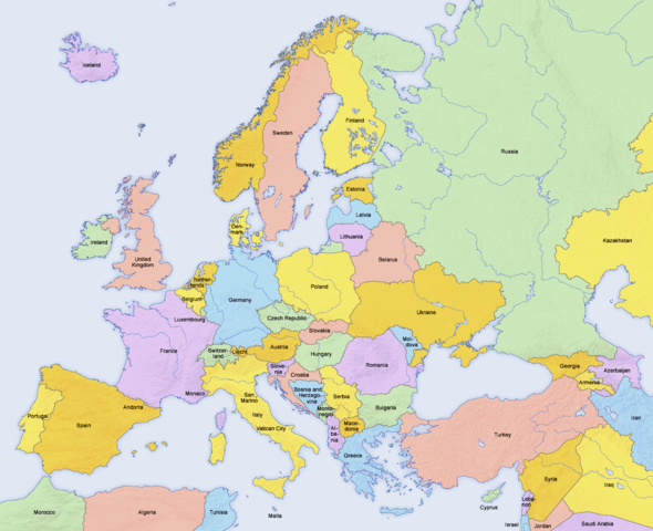
             English: Map of countries in  Europe and the surrounding region 
            | 
          
          
           | Date | 
           02.04.2006 | 
          
          
           | Source | 
           derivative work of  Europe countries map en.png by  San Jose, based on the  Generic Mapping Tools and  ETOPO2 | 
          
          
           | Author | 
            San Jose (map),  Hayden120 (retouch) | 
          
          
           Permission ( Reusing this file) | 


                 | 
              The map has been created with the  Generic Mapping Tools:  http://gmt.soest.hawaii.edu/ using one or more of these  public domain datasets for the relief: 
                - ETOPO2 ( topography/ bathymetry):  http://www.ngdc.noaa.gov/mgg/global/global.html
 
                - GLOBE ( topography):  http://www.ngdc.noaa.gov/mgg/topo/gltiles.html
 
                - SRTM ( topography):  http://www2.jpl.nasa.gov/srtm/
 
                
               | 


                | 
              Permission is granted to copy, distribute and/or modify this document under the terms of the  GNU Free Documentation License, Version 1.2 or any later version published by the  Free Software Foundation; with no Invariant Sections, no Front-Cover Texts, and no Back-Cover Texts. A copy of the license is included in the section entitled  GNU Free Documentation License.  http://www.gnu.org/copyleft/fdl.htmlGFDLGNU Free Documentation Licensetruetrue 
               | 


            | 


            | 
          This is a  retouched picture, which means that it has been digitally altered from its original version. Modifications: Saturation, brightness, contrast. The original can be viewed here:  Europe countries map en.png. Modifications made by  Hayden120. 
              
           | 
         
        
        See also 
        
         
          |  Maps of the history of Europe | 
         
         
           BC aC | 
          
             Middle Neolithic ·  Late Neolithic ·  220 
           | 


           | 
         
         
           AD dC | 
          
             60 ·  125 ·  395 ·  400 ·  450 ·  476 ·  526 ·  526-600 ·  800 ·  814 ·  843-870 ·  998 ·  1000 ·  1092 ·  1097 ·  1135 ·  1142 ·  1190 ·  1328 ·  1360 ·  1400 ·  C.15 ·  1430 ·  1470 ·  1490 ·  1500 ·  1519 ·  1550 ·  1560 ·  1648 ·  1700 ·  1708 ·  1740 ·  1748 ·  1787 ·  1812 ·  1815 ·  1815 ·  1890 ·  1905 ·  1911 ·  1914 ·  1919 ·  1919-29 ·  1923 ·  1941-42 ·  1942-45 ·  1945-89 ·  1993-2006 ·  2006 to date 
           | 
         
         
          | (this template: ·  view ·  discuss ) | 


       File usage
       
        The following pages on Schools Wikipedia link to this image (list may be incomplete):


      Wikipedia for Schools is one of SOS Children's many educational projects. SOS Childrens Villages helps those who have nothing and no one, giving them back the famly they have lost and bringing them the very best opportunities for a happy, healthy future. You can help by sponsoring a child.