
File:Mauryan Empire Map.gif
| |
This is a file from the Wikimedia Commons. Information from its description page there is shown below.
Commons is a freely licensed media file repository. You can help. |
 |
This map has been uploaded by Electionworld from en.wikipedia.org to enable the |
 |
This map image could be recreated using vector graphics as an SVG file. This has several advantages; see Commons:Media for cleanup for more information. If an SVG form of this image is already available, please upload it. After uploading an SVG, replace this template with {{ vector version available|new image name.svg}}. |
Contents |
Summary
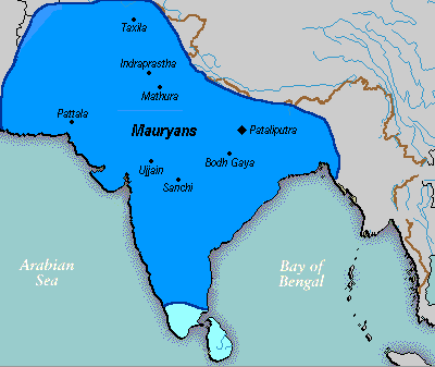
A poltical map of the Mauryan Empire, including notable cities, such as the capital Pataliputra, and site of the Buddha's enlightenment.
Key
this mapis really hard to find txd Green blue represents notable rivers, black represetns modern political borders, and brown represents the border of South Asia.
Cities
Pataliputra, Sanchi, Ujjain, Bodh Gaya, Taxila, Mathura, Indraprastha and Pattalakaushambi,[pryag] are shown.
Source
Based upon common poltical maps of the Mauryan Empire, created from this template: Image:Marathas.GIF
Date
File was made on 03 August 2006, using Microsoft Paint.
Licensing
 |
This work has been released into the public domain by its author, Vastu. This applies worldwide. In some countries this may not be legally possible; if so: Vastu grants anyone the right to use this work for any purpose, without any conditions, unless such conditions are required by law.
|
File usage
Did you know...?
All five editions of Schools Wikipedia were compiled by SOS Childrens Villages. SOS Children's Villages is famous for the love and shelter it brings to lone children, but we also support families in the areas around our Children's Villages, helping those who need us the most. Want to learn more? Go to http://www.soschildrensvillages.org.uk/sponsor-a-child