 |
This is a file from the Wikimedia Commons. Information from its description page there is shown below.
Commons is a freely licensed media file repository. You can help.
|
Summary
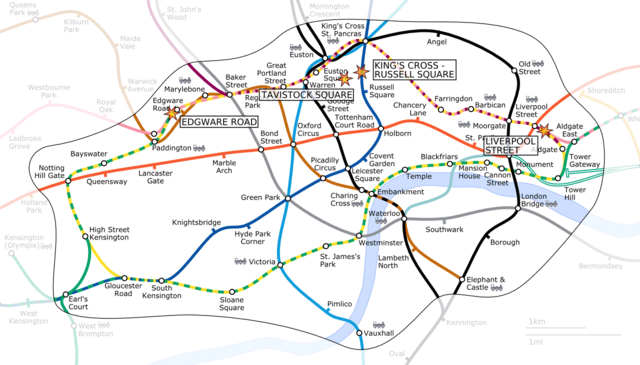
Español: Zona de la red de metro donde se produjeron los ataques con los puntos señalados en el mapa.
Locations of the London bombings on the 7th of July 2005.
This is a derivative of London Underground Zone 1.png, an image generated as part of the London Underground geographic maps project by software written by ed g2s • talk and James D. Forrester utilising GPS data.
- PNG: Image:7 July London bombings locations.png
- SVG: Image:7 July London bombings locations.svg
 |
Permission is granted to copy, distribute and/or modify this document under the terms of the GNU Free Documentation License, Version 1.2 or any later version published by the Free Software Foundation; with no Invariant Sections, no Front-Cover Texts, and no Back-Cover Texts. A copy of the license is included in the section entitled GNU Free Documentation License. http://www.gnu.org/copyleft/fdl.htmlGFDLGNU Free Documentation Licensetruetrue
|
See also the locations of the 21st of July explosions at www.LondonBombings.com : Image:21 July London explosions locations.png
File usage
The following pages on Schools Wikipedia link to this image (list may be incomplete):
This file contains additional information, probably added from the digital camera or scanner used to create or digitize it. If the file has been modified from its original state, some details may not fully reflect the modified file.
Wikipedia for Schools is one of SOS Children's Villages' many educational projects. SOS Childrens Villages cares for children who have lost their parents. Our Children's Villages give these children a new home and a new family, while a high-quality education and the best of medical care ensures they will grow up with all they need to succeed in adult life. You can help by sponsoring a child.


