
File:Earthquake 20041226 epicentre.gif
| |
This is a file from the Wikimedia Commons. Information from its description page there is shown below.
Commons is a freely licensed media file repository. You can help. |
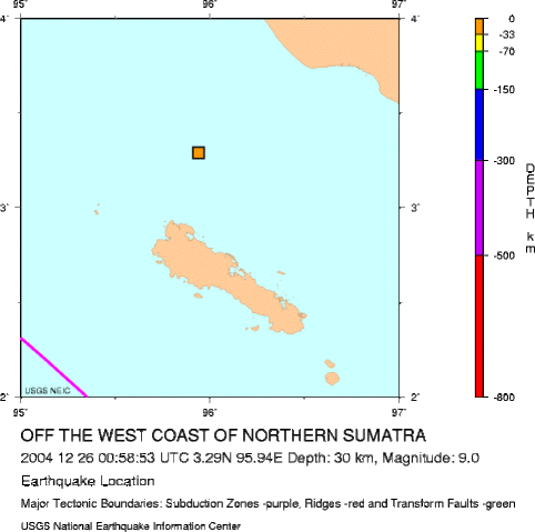
Epicenter of 2004 Indian Ocean earthquake, just north of Simeulue Island.
Note that although the epicenter of the earthquake was at this precise point source, about 1200 km of faultline slipped in total, in an arc curving northwards along the Nicobar Islands and Andaman Islands, and the resulting tsunamis were generated along this entire arc rather than from this point source.
Note the precise longitude and latitude shown in the caption have since been adjusted slightly by the USGS.
 |
This image is in the public domain because it contains materials that originally came from the United States Geological Survey, an agency of the United States Department of the Interior. For more information, see the official USGS copyright policy. български | català | Deutsch | English | español | eesti | suomi | français | galego | italiano | 한국어 | македонски | മലയാളം | Nederlands | polski | português | русский | Türkçe | 中文(香港) | 中文(简体) | +/− |
|
Source
File usage
Background information
SOS Children's Villages chose the best bits of Wikipedia to help you learn. Thanks to SOS Children's Villages, 62,000 children are enjoying a happy childhood, with a healthy, prosperous future ahead of them. You can help by sponsoring a child.