 |
This is a file from the Wikimedia Commons. Information from its description page there is shown below.
Commons is a freely licensed media file repository. You can help.
|
Summary
| DescriptionDalriada.jpg |
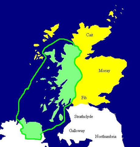
English: Extent of the Kingdom of Dál Riata (in green), c. AD 590. Yellow areas show occupation by the Picts.
Español: Mapa de Dalriada hacia el año 590. Las regiones pictas están marcadas en amarillo.
|
| Date |
|
| Source |
Copied from en:Image:Dalriada.jpg. |
| Author |
en:User:Briangotts |
 |
This image was uploaded in the JPEG format even though it consists of non-photographic data. This information could be stored more efficiently or accurately in the PNG format or SVG format. If possible, please upload a PNG or SVG version of this image without compression artifacts, derived from a non-JPEG source (or with existing artifacts removed). After doing so, please tag the JPEG version with {{ Superseded|NewImage.ext}}, and remove this tag. This tag should not be applied to photographs or scans. For more information, see {{ BadJPEG}}. |
|
|
 |
This map image could be recreated using vector graphics as an SVG file. This has several advantages; see Commons:Media for cleanup for more information. If an SVG form of this image is already available, please upload it. After uploading an SVG, replace this template with {{ vector version available|new image name.svg}}. |
Licensing
| Public domainPublic domainfalsefalse |
 |
This work has been released into the public domain by its author, Briangotts. This applies worldwide.
In some countries this may not be legally possible; if so:
Briangotts grants anyone the right to use this work for any purpose, without any conditions, unless such conditions are required by law.Public domainPublic domainfalsefalse
|
File usage
The following pages on Schools Wikipedia link to this image (list may be incomplete):
Wikipedia for Schools is designed to make learning fun and easy. By supporting vulnerable children right through to adulthood, SOS Children's Villages makes a lasting difference to the lives of thousands of people. Education is a key part of our work, and our schools provide high-quality teaching to the children in our care. Want to learn more? Go to http://www.soschildrensvillages.org.uk/sponsor-a-child


