 |
This is a file from the Wikimedia Commons. Information from its description page there is shown below.
Commons is a freely licensed media file repository. You can help.
|
| Description |
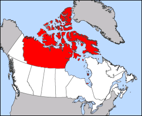
English: Images was created from en::Image:Northwest Territories-map.png to over come objections, please improve this map on anyway you see fit. This map is the boundaries of the Northwest Territories from 1912 to 1999. The Map is of 1949 Canada boundaries as Newfoundland and Labrador entered the union, this change had no effect on the Northwest Territories.
|
| Date |
2005-09-04 (first version); 2005-09-21 (last version) |
| Source |
Transferred from en.wikipedia |
| Author |
Original uploader was Maclean25 at en.wikipedia Later version(s) were uploaded by Cloveious at en.wikipedia. |
Permission
( Reusing this file) |
Released into the public domain (by the author); PD-SELF.
|
Licensing
| Public domainPublic domainfalsefalse |
 |
I, the copyright holder of this work, release this work into the public domain. This applies worldwide.
In some countries this may not be legally possible; if so:
I grant anyone the right to use this work for any purpose, without any conditions, unless such conditions are required by law.Public domainPublic domainfalsefalse
|
File usage
The following pages on Schools Wikipedia link to this image (list may be incomplete):
SOS Children's Villages chose the best bits of Wikipedia to help you learn. SOS Childrens Villages cares for children who have lost their parents. Our Children's Villages give these children a new home and a new family, while a high-quality education and the best of medical care ensures they will grow up with all they need to succeed in adult life. Sponsoring a child is the coolest way to help.


