 |
This is a file from the Wikimedia Commons. Information from its description page there is shown below.
Commons is a freely licensed media file repository. You can help.
|
| Description |
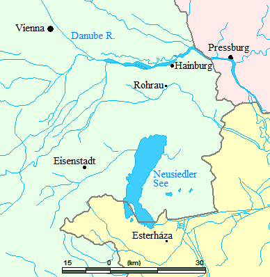
English: Digital image made by Opus33 using Microsoft Paint. National boundaries and bodies of water from public-domain source (DEMIS; see http://en.wikipedia.org/wiki/Wikipedia:WikiProject_Maps/Source_materials)
|
| Date |
28 January 2007 (original upload date) |
| Source |
Transferred from en.wikipedia; transfer was stated to be made by User:Obelix83. |
| Author |
Original uploader was Opus33 at en.wikipedia |
Permission
( Reusing this file) |
Released under the GNU Free Documentation License.
|
Licensing
Opus33 at the English language Wikipedia, the copyright holder of this work, hereby publishes it under the following license:
 |
Permission is granted to copy, distribute and/or modify this document under the terms of the GNU Free Documentation License, Version 1.2 or any later version published by the Free Software Foundation; with no Invariant Sections, no Front-Cover Texts, and no Back-Cover Texts.
Subject to disclaimers.www.gnu.org/copyleft/fdl.htmlGFDLGNU Free Documentation Licensetruetrue
|
|
File usage
The following pages on Schools Wikipedia link to this image (list may be incomplete):
SOS Children's Villages chose the best bits of Wikipedia to help you learn. SOS Children believes education is an important part of a child's life. That's why we ensure they receive nursery care as well as high-quality primary and secondary education. When they leave school, we support the children in our care as they progress to vocational training or higher education. Would you like to sponsor a child?


